

![]()
![]() Maribor
- Location (please also see where
is Maribor and how
to get to Maribor).
Maribor
- Location (please also see where
is Maribor and how
to get to Maribor).
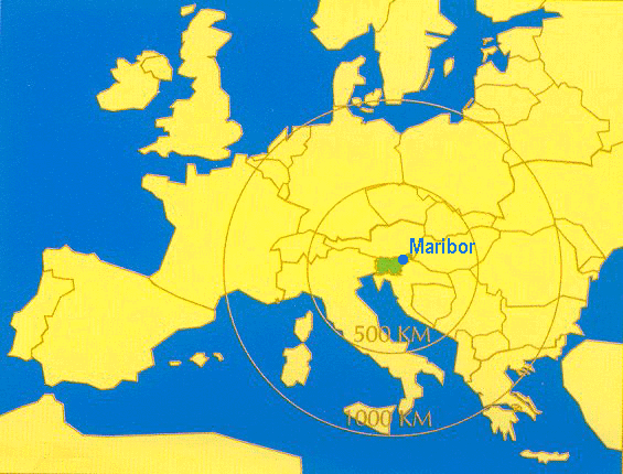
Maribor is situated 269.5
m above sea level, 15° 39' 12" E longitude and 46°
33' 39" N latitude, as measured from the southwest
corner of the Castle chapel. The
city 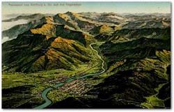 fans out along both banks of
the Drava river. Entire regions form a contiguous whole:
fans out along both banks of
the Drava river. Entire regions form a contiguous whole:
- the Drava valley between the Pohorje and Kozjak mountain chains spreads out at Selnica into a broader diluvial lowland of the Maribor Plain;
- Slovenske gorice, hills of the Tertiary geological period, are camposed of Miocene marl and sandstone;
- the Drava-Ptuj Field, which forms a giant triangle, extends as a large mound of gravel diluvial sediments towards Ptuj.
![]() The Drava
river, formed by a glacier, deposited large quantities of
gravel, which in turn formed a characteristic Mariborian
landscape of terraces. To the north, Maribor is ringed by
the surroundings hills that are enhanced by vineyards
that occupy acreage extending into Maribor itself, thus
lending the city a special charm.
The Drava
river, formed by a glacier, deposited large quantities of
gravel, which in turn formed a characteristic Mariborian
landscape of terraces. To the north, Maribor is ringed by
the surroundings hills that are enhanced by vineyards
that occupy acreage extending into Maribor itself, thus
lending the city a special charm.
![]() To the
southwest, Maribor is protected by the eastern slope of
the Pohorje mountain chain. At the Pohorje
foothills, a separate "little mountain" (the
tonalite Pekrska Gorca, 352 m) with its famous vineyards,
is situated.
To the
southwest, Maribor is protected by the eastern slope of
the Pohorje mountain chain. At the Pohorje
foothills, a separate "little mountain" (the
tonalite Pekrska Gorca, 352 m) with its famous vineyards,
is situated.
![]() Maribor is
located at the junction of two natural routes. The first
is the river Drava, which divides the city in to north
and southpart. In former times, the Drava river was
mainly used for the transportation of assorted cargo on
covered barges and rafts. Parallel to the Drava river was
a service road and a railway line. The second, from a
meridian-wise direction, is the route across the Drava
river from the Gradec Basin towards the Celje Basin. The
highway and the railway through Maribor connect Central
and southeastern Europe.
Maribor is
located at the junction of two natural routes. The first
is the river Drava, which divides the city in to north
and southpart. In former times, the Drava river was
mainly used for the transportation of assorted cargo on
covered barges and rafts. Parallel to the Drava river was
a service road and a railway line. The second, from a
meridian-wise direction, is the route across the Drava
river from the Gradec Basin towards the Celje Basin. The
highway and the railway through Maribor connect Central
and southeastern Europe.
![]() Maribor's
geographical location determined the city's development.
The old core of the city is found between gently sloping
Drava river - formed terraces and
Maribor's
geographical location determined the city's development.
The old core of the city is found between gently sloping
Drava river - formed terraces and 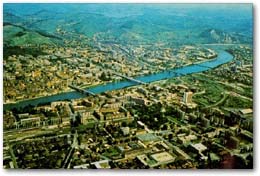 the
vineyard hills to the north. Maribor's layout suggests a
rectangular network of rows of buildings and traffic
systems in northsouth and east-west directions. In the
nineteenth century the city started to spread towards
Meljski hrib (Melje Hill). In this century, it has
centered below the Pohorje mountain in two elongated
ribbons on both sides of the Strazunski gozd (Strazun
forest) to the southeast. Unfortunately, this growth has
been too haphazard and thus has not been accompained by
adequately planned urbanization. This is why even to this
day almost all crucial urban components of the city are
still located on the left bank of the Drava river, in the
old city nucleus, or adjacent to it.
the
vineyard hills to the north. Maribor's layout suggests a
rectangular network of rows of buildings and traffic
systems in northsouth and east-west directions. In the
nineteenth century the city started to spread towards
Meljski hrib (Melje Hill). In this century, it has
centered below the Pohorje mountain in two elongated
ribbons on both sides of the Strazunski gozd (Strazun
forest) to the southeast. Unfortunately, this growth has
been too haphazard and thus has not been accompained by
adequately planned urbanization. This is why even to this
day almost all crucial urban components of the city are
still located on the left bank of the Drava river, in the
old city nucleus, or adjacent to it.
For most of the year, Maribor enjoys a pleasant Pannonian climate. Winters tend to be cold. Spring comes early. Summers are hot and autumns warm.
![]() Rainfalls
Rainfalls
The yearly rainfall averages 1055 mm; mostly it rains
in May, June, and July. The autumn months are relatively
dry.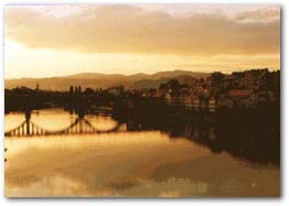
Maribor offers many pleasant, sunny days; on average we have some 266 sun-filled days in a year. There is not much fog in Maribor, but with heavy humidity and cloudiness on the increase, fog does tend to settle on the city, mainly in the months of November and December.
![]() Wind
Wind
Maribor receives mostly northwestern, southeastern, northern, and southern winds. During the night, most frequently, the northwestern wind blows from the Drava valley; at daytime it is the southeastern wind. These winds bring to the city the clear mountain air. They clear the air above the city, which from time to time can be very badly polluted by industry. Maribor, in general, is very well protected against unpleasant biting winds, as well as against floods.