

![]()
![]() Maribor - Kamnica - Mariborski otok
- Mariborsko jezero
Maribor - Kamnica - Mariborski otok
- Mariborsko jezero
In Maribor, we start from Glavni trg, go along Koroska cesta and Strossmayerjeva ulica, continuing along Gosposvetska and Vrbanska -passing by The Faculty of Agriculture (Fakulteta za kmetijstvo),in the vicinity of which there is a row of chestnut trees with large crowns. In the direct vicinity, Vrbanska cesta is surrounded on both sides by one of the longest chestnut tree rows in Slovenia. On the Vrbansko plateau, in the direct vicinity of the street, Maribor Water Supply plants are located. The city receives most of its drinking water from the Vrbansko plateau. On the vineyard slopes, we can notice Racji Dvor, which is mentioned for the first time in the beginning of XIII century, from quite a distance. It was owned by the Admont Monastery. In its present form, the castle is a characteristic early-classicist construction. A museum with Slovenian rural architectural buildings is being arranged presently in the direct vicinity of Racji dvor.
We continue along Vrbanska cesta. The road goes downwards into the Vinarski potok (Wine Creek) Valley. Close by, the race track premises are located, where sports tournaments take place. Riding horses for hire is also possible. From the race track, we arrive at pleasant Kamnica, surrounded by vineyards and fruit orchards.
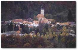 The area of Kamnica was inhabited
in age-old times, as is testified to by findings from the Bronze Age.
As a settlement, Kamnica is mentioned around 1100 for the first time,
when St. Martin's Church stood here. It was basically an early Gothic
building, which was later rebuilt many a time. During the XVIII century,
it was renewed in the Baroque style, a bell tower was added, and it was
enlarged as well. The interiors of the Church are decorated by fine frescoes
from the middle of the XVII century. By the church, we go downhill towards
the main road Maribor - Dravograd. The Maribor Island is in the direct
vicinity of Kamnica on the Drava. It was formed by rapid currents which
are due to a diminished capacity for transport, where the river began
to deposit sand and gravel. It is an exceptional example of a river island
in our country. A wide variety of vegetation is characteristic of the
island,as 15 tree and 20 shrub species are to be found there, including
some rare relict ones. Since 1930, there has been a summer beach on the
island, with an open pool of Olympic dimensions, as well as smaller ones,
a jump, a water slide and other facilities. During the summer season,
it represents one of the most frequented recreational spots in Maribor
. Interestingly, once the area of the island was larger by a fourth. In
1946, a high water elevation, due to the construction of a nearby electric
power station, caused the land to disappear under the pressure of water
. Thus later a concrete pier was made in the direction of the electric
power station. The pier ends with a barrage. The latter stops erosion,
which is a problem when the water elevation is high. The electric power
station was begun to be constructed during the German occupation in 1942,
pertaining to the needs of the bauxite and aluminium manufacturing factory
in Kidricevo. The construction was completed in 1948, though completely
finalized in 1961. It mean yearly production amounts to 264 Gwh. Behind
the electric power station, the artificial Maribor lake was formed, which
is today a popular recreation area for certain water sports (sailing,
surfing rowing). Maribor lake is, due to its unique landscape appearance
and due to its peculiar water biological entities, declared a regional
park by municipality decree.
The area of Kamnica was inhabited
in age-old times, as is testified to by findings from the Bronze Age.
As a settlement, Kamnica is mentioned around 1100 for the first time,
when St. Martin's Church stood here. It was basically an early Gothic
building, which was later rebuilt many a time. During the XVIII century,
it was renewed in the Baroque style, a bell tower was added, and it was
enlarged as well. The interiors of the Church are decorated by fine frescoes
from the middle of the XVII century. By the church, we go downhill towards
the main road Maribor - Dravograd. The Maribor Island is in the direct
vicinity of Kamnica on the Drava. It was formed by rapid currents which
are due to a diminished capacity for transport, where the river began
to deposit sand and gravel. It is an exceptional example of a river island
in our country. A wide variety of vegetation is characteristic of the
island,as 15 tree and 20 shrub species are to be found there, including
some rare relict ones. Since 1930, there has been a summer beach on the
island, with an open pool of Olympic dimensions, as well as smaller ones,
a jump, a water slide and other facilities. During the summer season,
it represents one of the most frequented recreational spots in Maribor
. Interestingly, once the area of the island was larger by a fourth. In
1946, a high water elevation, due to the construction of a nearby electric
power station, caused the land to disappear under the pressure of water
. Thus later a concrete pier was made in the direction of the electric
power station. The pier ends with a barrage. The latter stops erosion,
which is a problem when the water elevation is high. The electric power
station was begun to be constructed during the German occupation in 1942,
pertaining to the needs of the bauxite and aluminium manufacturing factory
in Kidricevo. The construction was completed in 1948, though completely
finalized in 1961. It mean yearly production amounts to 264 Gwh. Behind
the electric power station, the artificial Maribor lake was formed, which
is today a popular recreation area for certain water sports (sailing,
surfing rowing). Maribor lake is, due to its unique landscape appearance
and due to its peculiar water biological entities, declared a regional
park by municipality decree.
![]()